VERY IMPORTANT… guys…
![Source: FEMA Regions Risk Map [ http://www.fema.gov/risk-mapping-assessment-planning/regional-contact-information ]](https://thecomplexlayersseries.com/wp-content/uploads/2014/10/cregmap-fema-regions-map.gif)
Source: FEMA Regions Risk Map [ http://www.fema.gov/risk-mapping-assessment-planning/regional-contact-information ]
……….Please, try and set aside 1 hour and 46 minutes to listen to and view slides to this very important FEMA REGION II Pandemic Webinar I : Federal and Local Government Planning…Hosted in conjunction with SIFMA – held on Sept. 23, 2014…
……….This has everything to do with YOUR LIFE and their plans set in place to protect, organize, handle, control, conduct operations of each portion of infrastructure, ALL forms of metro, suburb, and rural transportation not limited to-but-including the aviation sector–ferry & all ports–taxi services and your personal vehicle travel & toll pass cards, ALL school districts’ operations including-but-not limited to public and private school bus service & family vehicle drop offs, ALL areas of everyday life needs and services-including-but-not limited to such sectors as Food Supply & Distribution including import-export-trucking, ALL Utilities – Water, gas/propane, electricity, ALL merchandise retail operations, goods & services, ALL forms of hospitality & lodging, banking….etc…and more!….everything is discussed and thus has been implemented.
This is more in-depth than anything being given ‘piece-meal’ on this important Pandemic subject matter in the mainstream news…..this is directly from the infrastructure directors and managers themselves.
Stay ahead of the pack! Click on the link to this very important and very informative Pandemic Webinar they have conducted. Not many civilians in Region II are aware of this…but you will be….and can help advise others. See the link below to their webinar and also a link to the FEMA and Red Cross regions map.
1. FEMA REGION II Pandemic Webinar I : Federal and Local Government Planning…Hosted in conjunction with SIFMA – Sept. 23, 2014…
https://share.dhs.gov/p7b0mlqsepi
2. FEMA and Red Cross regions map
http://maps.redcross.org/website/maps/images/NationalLevel/FEMA_Regions.pdf
Just a note here…..it is rather interesting how this pandemic webinar took place on September 23, 2014…….and……on September 24th was when the man from Liberia, Mr. Duncan, who was visiting his family in Dallas, went to the hospital the FIRST TIME because he was feeling sick, and yet the hospital misdiagnosed him…when he indeed had EBOLA. The webinar seems to have been held just at the right time….hmmmm.
Here is a very good “workplace” pandemic preparedness illustration graphic below, which could also be used for home and school use too, if properly adjusted and applied to each environment. [Graphic Source: Pandemic Planning Visual Summary. New Zealand Ministry of Health. http://www.officehygiene.co.nz/pandemic_planning/pandemic-visual-summary.jpg ].
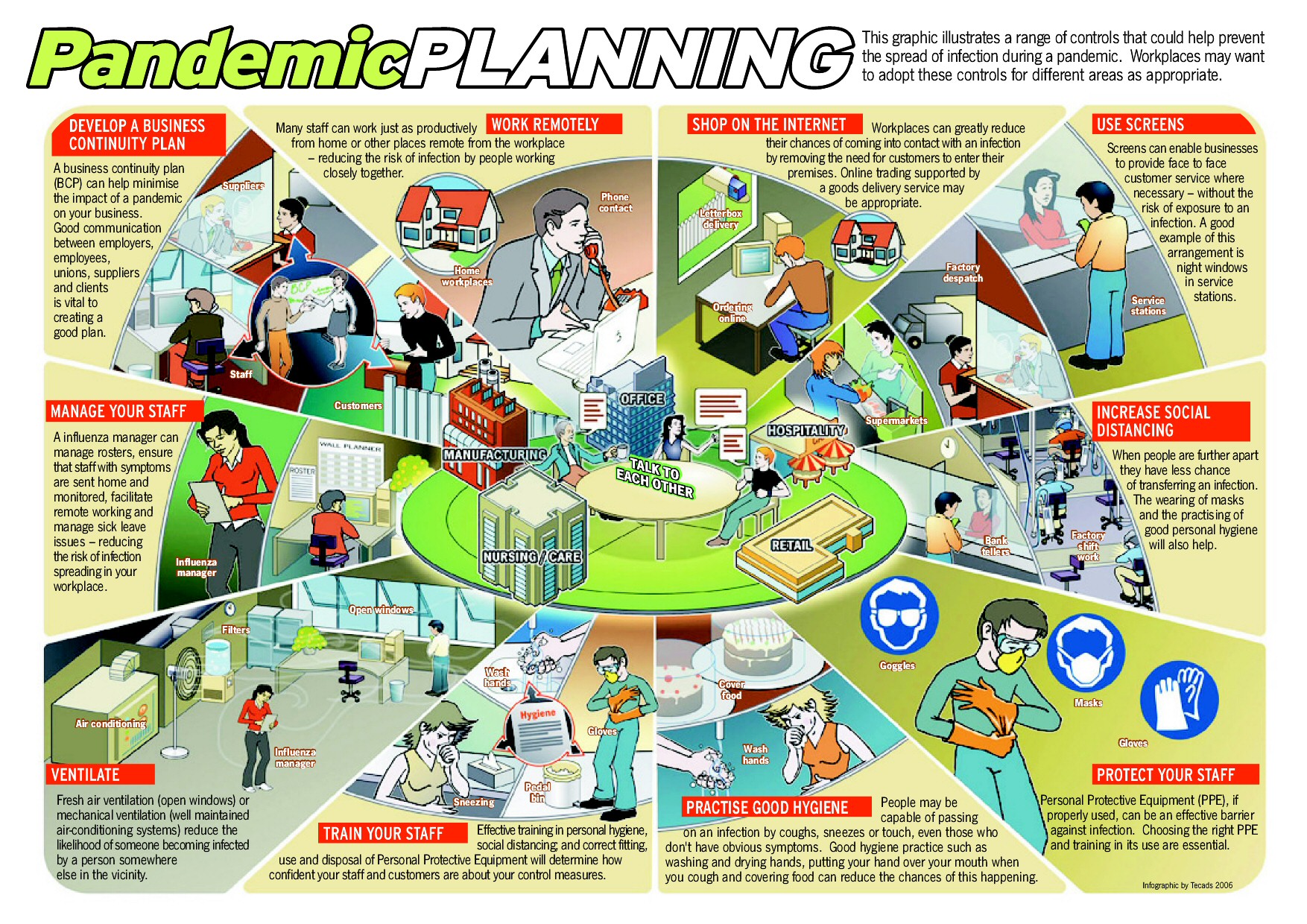
Source: New Zealand Ministry of Health, Pandemic Preparedness Planning Visual Summary
Stay safe and let’s continue to stay informed by sharing important information!
May Yah and Yahusha’s peace and protection be with you and your loved ones, always.
Tonya M. Woodbury Sloan
The Complex Layers Series
Sources cited within post.
